Part 4
Geocaching and Route Planning - Part 4
Previously on Geocaching and Route Planning (Part 1), we planned a geocaching trip from Austin to San Antonio, Texas. We wanted to hit all caches that was only 2 miles from I-35. In Geocaching and Route Planning (Part 2), we showed how to build the ARC filter file with MapSend or Mapsource. With Geocaching and Route Planning (Part 3), we created the ARC filter file with Google Maps.
In this edition of Geocaching and Route Planning, we will show how to build the ARC filter file using Google Earth.
Google Earth is a Windows based application which is downloaded here.
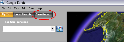
After launching Google Earth, select "Directions" to bring up the start and end location input fields.
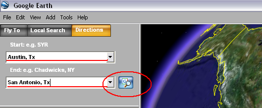
Once there, we enter our starting and ending address. In this case we're using "Austin, TX" for starting and "San Antonio, TX" for ending. Select the "Search" button when done.
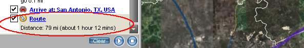
In the turn-by-turn list box (below the search input fields), there should be a entry called "Route". It should already be highlighted but click it if it is not.
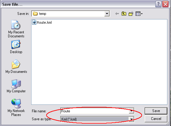
We need to save the route to a output file. Do this by selecting "File" off of the main menu then select "Save As". This will bring up the Save As dialog box. Enter a name and switch the output format to "KML" instead of "KMZ" then click "Save".
Now that we have the google earth route file, let's build the ARC filter file:
gpsbabel -i kml -f route.kml -o arc -F googleearthroute.arc
We can then input the ARC filter file into the command as in Part 1:
gpsbabel -i gpx -f all.gpx -x arc,file=googleearthroute.arc,distance=2M -o gpx -F route.gpx
That's all there is to it.